
One Bay Area Plan
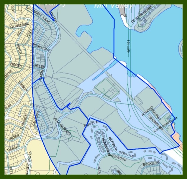
Tam Valley & Almonte Parcels in the Priority Development Area (PDA)
The Tam Valley & Almonte parcels that are included in
the Hwy 101 Corridor PDA are shaded and outlined in blue
The One Bay Area Plan is in the process of being finalized and is a state required Bay Area regional plan that will plan for transportation, housing and land use over the next 25 years. It concentrates high-density, mixed-use commercial and affordable housing near transit hubs. The plan concentrates the majority of this development in Priority Development Areas, also know as PDAs.
**The Tam Valley and Almonte lowlands, which are located within a ½ mile from Hwy 101, are included in the Hwy 101 Corridor Priority Development Area (PDA) (see above map).
The One Bay Area Plan has not yet been adopted but will be soon, specifically in June 2013. So, although not much time, there is still time to change this plan. Read below to learn what changes we want to make and why.
Background Information about RHNA
“Regional Housing Needs Allocation (RHNA) is a state mandated process for determining how many housing units, including affordable units, each community must plan to accommodate. The California Department of Housing and Community Development (HCD) determines the total housing need for a region, and it is the Association of Bay Area Government’s (ABAG's) responsibility to distribute this need to local governments. Working with local governments, ABAG developed an allocation methodology for assigning units, by income category, to each city and county in the nine-county Bay Area. This allocation of need shows local governments the total number of housing units, by affordability, for which they must plan in their Housing Elements for each planning period. Allocations for each jurisdiction are published in the annual housing report.” (http://www.abag.ca.gov/housing-top.html)
Background Information about SB 375
California State Senate Bill (SB) 375 was signed into law in 2008. “SB 375 requires that our Regional Transportation Plan (RTP) contain a Sustainable Communities Strategy (SCS) that integrates land-use planning and transportation planning. For the 25-year period covered by the Regional Transportation Plan, the Sustainable Communities Strategy must identify areas within the nine-county Bay Area sufficient to house all of the region’s population, including all economic segments of the population. It must also attempt to coordinate the resulting land- use pattern with the transportation network so as to reduce per capita greenhouse-gas emissions from personal-use vehicles (automobiles and light trucks).” (Bay Area Plan – Initial Vision Plan 2011 by ABAG & MTC: Page 1)
ABAG’s & MTC’s Implementation of the Sustainable Communities Strategy
Two major regional planning agencies – the Association of Bay Area Governments (ABAG) and Metropolitan Transportation Commission (MTC) are leading the Sustainable Communities Strategy process for the Bay Area Region, with the creation of Plan Bay Area.
The Plan Bay Area – Job Housing Connection Strategy concentrates the majority of development in Priority Development Areas (PDAs) (areas in close proximity to public transit). SB 375 requires that the Regional Housing Needs Allocation (RHNA) be consistent with the Sustainable Communities Strategy (SCS). Subsequently, when selecting sites for Regional Housing Needs Allocation (RHNA) residential units, local jurisdictions are encouraged to select sites that are located within PDAs.
“What are Priority Development Areas?
Priority Development Areas (PDAs) are locally-identified, infill development opportunity areas within existing communities. They are generally areas of at least 100 acres where there is local commitment to developing more housing along with amenities and services to meet the day-to-day needs of residents in a pedestrian-friendly environment served by transit. To be eligible to become a PDA, an area had to be within an existing community, near existing or planned fixed transit or served by comparable bus service, and planned for more housing." (Excerpt from Focus Newsletter)
Where are the Priority Development Areas?
More than 60 jurisdictions (plus several Congestion Management Agencies) submitted applications for well over 100 PDAs. The areas nominated include most of the places in the Bay Area served by fixed transit, major bus corridors, or planned transit under MTCʼs Resolution 3434. Together, these areas comprise about 115,000 acres of urban and suburban land, less than 5 percent of the Bay Area's total land area.” However, even though this is a small proportion of the region's land area, “the PDAs are expected to accommodate 80% (or over 525,570 units) of new housing, and 66% (or 744, 230) of new jobs. Overall, well over two-thirds of all regional growth over the next 30 years is allocated within Priority Development Areas.” (Excerpt from Plan Bay Area – Jobs Housing Connection Strategy)
More specifically, between now and 2040, Marin County is supposed to accommodate an unrealistic amount of growth, specifically 7510 new housing units and 18,390 new jobs. “In Marin, 22% of new jobs and 38% of new housing are anticipated in PDAs.” (Excerpt from Plan Bay Area – Jobs Housing Connection Strategy) Yet, Marinʼs PDAs comprise only a very small fraction of land designated for development. The result will be concentrated high-density development in Marinʼs PDAs.
How is the One Bay Area Plan, which targets the majority of development and growth (including the RHNA) in Priority Development Areas (PDAs), enforced?
Senate Bill 375 requires that the Regional Housing Needs Allocation (RHNA) be consistent with Plan Bay Area (the Bay Area's Sustainable Communities Strategy). In addition, SB 375 uses incentives (I.e. transportation funding, etc.) and penalties (I.e. court sanctions; accelerated Housing Element update cycles, etc.) to entice local jurisdictions to comply with Plan Bay Area.
Moreover, SB-375 and Plan Bay Area incentivize developers to build in PDAs. SB 375 adjusts CEQA and streamlines or exempts Environment Impact Reports (EIRs) for projects that are consistent with an approved Sustainable Community Strategy (SCS) such as Plan Bay Area. In addition, the One Bay Area Grant (OBAG) will distribute $325 million over a four year period among the regionʼs Congestion Management Agencies (CMAs) to fund locally-tailored projects that support communities accommodating new housing growth in proximity to transit. At least 70% of OBAG funds will support investments in PDAs within the regionʼs largest counties. In the four North Bay counties, at least 50% of funds will support projects in PDAs. OBAG funding is in addition to transportation funding and will buttress the major regional investments identified in the Draft Transportation Investment Strategy—many of which reinforce or expand service in PDAs.
Thus, jurisdictions are coerced into targeting the majority of their development and growth (including the RHNA) in Priority Development Areas (PDAs) and developers are incentivized to build in Priority Development Areas (PDAs).
How Being Included in the Hwy 101 PDA affects Tam Valley and Almonte
As already mentioned, the Tam Valley and Almonte lowlands, which are within 1⁄2 mile from Highway 101, are included in the Highway 101 Corridor Priority Development Area (PDA). As Plan Bay Area implements SB 375ʼs Sustainable Communities Strategy, it mandates Marin County to plan for concentrated development, especially high- density affordable housing, in the PDAs and then gives incentives to developers to construct such development in those PDAs. Therefore, as long as Tam Valley & Almonte remain in the Hwy 101 Corridor PDA, these districts will be targeted for accelerated high-density development and growth.
Does this make sense?
No! In the Tam Valley and Almonte lowlands, there are multitudinous constraints to development. These constraints include hazardous conditions (unacceptable traffic levels, flooding, projected sea level rise, high seismic activity, high liquefaction, subsidence, & mud displacement) and insufficient infrastructure, public services, retail & professional services and public transit as well as proximity to vulnerable natural habitat & endangered species. Encouraging new residential development, especially high density development, in these lowlands would increase the risk of undue harm to the environment and undue hardship, illness &/or injury to the residents.
Our Goal
Therefore, Sustainable TamAlmonte advocates the removal of Tam Valley and Almonte from the Highway 101 Corridor Priority Development Area.